![Product Links PDF (4.6MB) - Static viewing and printing SHAPEFILE - Download a Shapefile of data WEBMAP - Dynamic viewing in a browser GEODATABASE - Download data in the ESRI format This map illustrates satellite-detected flash floods and landslides in Melamchi village, Melamchi Municipality, Bagmati province, Nepal as observed using Sentinel-2 satellite imagery acquired on 24 June 2021. Within the analyzed area, approximately 150 structures appear to be potentially affected by the landslides. This is a preliminary analysis and has not yet been validated in the field. Please send ground feedback to United Nations Satellite Centre (UNOSAT). Satellite Data: Sentinel-2 Imagery Dates: 24 June 2021 at 05:10 UTC Resolution: 10 m Copyright: Contains modified Copernicus Sentinel Data [2021] Source: ESA Administrative boundaries: Boundary data: Survey Department of Nepal, UN Resident Coordinators Office in Nepal, HDX Populated place: OpenStreetMap Road data: OpenStreetMap Background: ESRI World Imagery Analysis: United Nations Satellite Centre (UNOSAT) Production: United Nations Satellite Centre (UNOSAT)](/sites/default/files/inline-images/UNOSAT_A3_Natural_Portrait_FL20210630NPL_Melamchi_Landslide_24062021.jpg)
Product Links
PDF (4.6MB) - Static viewing and printing
SHAPEFILE - Download a Shapefile of data
WEBMAP - Dynamic viewing in a browser
GEODATABASE - Download data in the ESRI format
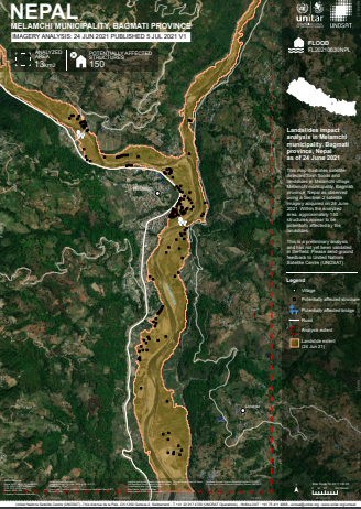
This map illustrates satellite-detected flash floods and landslides in Melamchi village, Melamchi Municipality, Bagmati province, Nepal as observed using Sentinel-2 satellite imagery acquired on 24 June 2021. Within the analyzed area, approximately 150 structures appear to be potentially affected by the landslides.
This is a preliminary analysis and has not yet been validated in the field. Please send ground feedback to United Nations Satellite Centre (UNOSAT).
Satellite Data: Sentinel-2
Imagery Dates: 24 June 2021 at 05:10 UTC
Resolution: 10 m
Copyright: Contains modified Copernicus Sentinel Data [2021]
Source: ESA
Administrative boundaries: Boundary data: Survey Department of Nepal, UN Resident Coordinators Office in Nepal, HDX
Populated place: OpenStreetMap
Road data: OpenStreetMap
Background: ESRI World Imagery
Analysis: United Nations Satellite Centre (UNOSAT) Production: United Nations Satellite Centre (UNOSAT)
Click here